![](/images/other/stat-length.png)
![Randonnée Vélo de route Les Abrets en Dauphiné - Boucle départ la bâtie Divisin - Photo](https://media.geolcdn.com/t/1900/400/ext.pjpeg?maxdim=2&url=https%3A%2F%2Fstatic1.geolcdn.com%2Fsiteimages%2Fupload%2Ffiles%2F1524743154velo.jpg)
Boucle départ la bâtie Divisin
choubaka77
Utilisateur
![Longueur](/images/other/stat-length.png)
Longueur
30 km
![Altitude max](https://static1.geolcdn.com/siteimages/upload/files/1508320355ic_sort_altitude_max_24dp.png)
Altitude max
621 m
![Dénivelé positif](https://static1.geolcdn.com/siteimages/upload/files/1508320355ic_sort_den_pos_24dp.png)
Dénivelé positif
469 m
![Km-Effort](/images/other/stat-length.png)
Km-Effort
36 km
![Altitude min](https://static1.geolcdn.com/siteimages/upload/files/1508320355ic_sort_altitude_min_24dp.png)
Altitude min
438 m
![Dénivelé négatif](https://static1.geolcdn.com/siteimages/upload/files/1508320355ic_sort_den_neg_24dp.png)
Dénivelé négatif
469 m
![Boucle](https://static1.geolcdn.com/siteimages/upload/files/16400158638029165_repeat_loop_refresh_sync_direction_icon.png)
Boucle
Oui
Date de création :
2024-06-09 08:29:21.0
Dernière modification :
2024-06-09 10:17:25.514
![Vélo de route](https://static1.geolcdn.com/sitytour/trail-icons/201.png)
1h47
Difficulté : Moyen
![Scannez ce code QR pour ouvrir la randonnée dans l'application SityTrail](https://capi.geolives.com/qq0zvz2zws4bq2lad0pu/sitytour/trails/4084643/qr.png?size=200)
Application GPS de randonnée GRATUITE
À propos
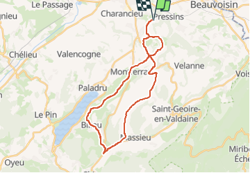
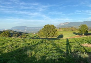
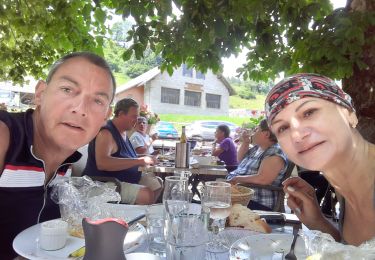
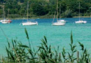
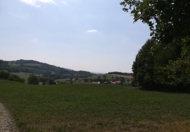
Randonnée Vélo de route de 30 km à découvrir à Auvergne-Rhône-Alpes, Isère, Les Abrets en Dauphiné. Cette randonnée est proposée par choubaka77.
Description
Boucle très sympathique qui alterne les joies du vélo et le plaisir des yeux
Localisation
Pays :
France
Région :
Auvergne-Rhône-Alpes
Département/Province :
Isère
Commune :
Les Abrets en Dauphiné
Localité :
La Bâtie-Divisin
Départ:(Dec)
Départ:(UTM)
704120 ; 5044220 (31T) N.
Commentaires
Randonnées à proximité
![Randonnée Marche Velanne - Boucle autour de sauge - Photo](https://media.geolcdn.com/t/375/260/804bbea8-b5ac-447b-b9b3-5a79a27bbb0f.jpg&format=jpg&maxdim=2)
![Marche Marche](https://static1.geolcdn.com/sitytour/trail-icons/101.png)
Boucle autour de sauge
Marche
Très facile
Velanne,
Auvergne-Rhône-Alpes,
Isère,
France
![](/images/other/stat-length.png)
5,7 km | 7,2 km-effort
1h 33min
![](https://static1.geolcdn.com/siteimages/upload/files/16400158638029165_repeat_loop_refresh_sync_direction_icon.png)
Oui
![Randonnée Vélo de route Villages du Lac de Paladru - Cucheron 21 - Photo](https://media.geolcdn.com/t/375/260/1b7eb286-a0cc-491f-b4fe-44003a7aefc5.jpg&format=jpg&maxdim=2)
![Vélo de route Vélo de route](https://static1.geolcdn.com/sitytour/trail-icons/201.png)
Cucheron 21
Vélo de route
Moyen
Villages du Lac de Paladru,
Auvergne-Rhône-Alpes,
Isère,
France
![](/images/other/stat-length.png)
97 km | 126 km-effort
4h 57min
![](https://static1.geolcdn.com/siteimages/upload/files/16400158638029165_repeat_loop_refresh_sync_direction_icon.png)
Non
![Randonnée Marche Montferrat - Pays Voironnais - Circuit GPS de la Roselière - Photo](https://media.geolcdn.com/t/375/260/ext.jpg?maxdim=2&url=https%3A%2F%2Fservices.sitytrail.com%2FGeolivesWS%2FDownloadMedia.ashx%3FTrailID%3D109068%26Media%3D3101_1.jpg)
![Marche Marche](https://static1.geolcdn.com/sitytour/trail-icons/101.png)
Pays Voironnais - Circuit GPS de la Roselière
Marche
Difficile
Montferrat,
Auvergne-Rhône-Alpes,
Isère,
France
![](/images/other/stat-length.png)
12 km | 16,6 km-effort
2h 45min
![](https://static1.geolcdn.com/siteimages/upload/files/16400158638029165_repeat_loop_refresh_sync_direction_icon.png)
Oui
![Randonnée Vélo de route Les Abrets en Dauphiné - Lac de paladru au départ de la bâtie - Photo](https://media.geolcdn.com/t/375/260/ext.jpg?maxdim=2&url=https%3A%2F%2Fstatic1.geolcdn.com%2Fsiteimages%2Fupload%2Ffiles%2F1524743154velo.jpg)
![Vélo de route Vélo de route](https://static1.geolcdn.com/sitytour/trail-icons/201.png)
Lac de paladru au départ de la bâtie
Vélo de route
Facile
Les Abrets en Dauphiné,
Auvergne-Rhône-Alpes,
Isère,
France
![](/images/other/stat-length.png)
29 km | 35 km-effort
1h 34min
![](https://static1.geolcdn.com/siteimages/upload/files/16400158638029165_repeat_loop_refresh_sync_direction_icon.png)
Oui
![Randonnée Marche Villages du Lac de Paladru - Paladru sortie FFR - Photo](https://media.geolcdn.com/t/375/260/ext.jpg?maxdim=2&url=https%3A%2F%2Fstatic1.geolcdn.com%2Fsiteimages%2Fupload%2Ffiles%2F1553511878bg_sport_marche.png)
![Marche Marche](https://static1.geolcdn.com/sitytour/trail-icons/101.png)
Paladru sortie FFR
Marche
Moyen
Villages du Lac de Paladru,
Auvergne-Rhône-Alpes,
Isère,
France
![](/images/other/stat-length.png)
6,6 km | 9,2 km-effort
1h 45min
![](https://static1.geolcdn.com/siteimages/upload/files/16400158638029165_repeat_loop_refresh_sync_direction_icon.png)
Non
![Randonnée Randonnée équestre Pressins - 202210 RallyePressins J2 - Photo](https://media.geolcdn.com/t/375/260/ext.jpg?maxdim=2&url=https%3A%2F%2Fstatic1.geolcdn.com%2Fsiteimages%2Fupload%2Ffiles%2F1524743154cheval.jpg)
![Randonnée équestre Randonnée équestre](https://static1.geolcdn.com/sitytour/trail-icons/301.png)
202210 RallyePressins J2
Randonnée équestre
Moyen
Pressins,
Auvergne-Rhône-Alpes,
Isère,
France
![](/images/other/stat-length.png)
15,7 km | 21 km-effort
2h 30min
![](https://static1.geolcdn.com/siteimages/upload/files/16400158638029165_repeat_loop_refresh_sync_direction_icon.png)
Oui
![Randonnée Randonnée équestre Pressins - 202210 RallyePressin J1 - Photo](https://media.geolcdn.com/t/375/260/ext.jpg?maxdim=2&url=https%3A%2F%2Fstatic1.geolcdn.com%2Fsiteimages%2Fupload%2Ffiles%2F1524743154cheval.jpg)
![Randonnée équestre Randonnée équestre](https://static1.geolcdn.com/sitytour/trail-icons/301.png)
202210 RallyePressin J1
Randonnée équestre
Moyen
Pressins,
Auvergne-Rhône-Alpes,
Isère,
France
![](/images/other/stat-length.png)
26 km | 33 km-effort
3h 30min
![](https://static1.geolcdn.com/siteimages/upload/files/16400158638029165_repeat_loop_refresh_sync_direction_icon.png)
Oui
![Randonnée Randonnée équestre Les Abrets en Dauphiné - 202210 ApprochePressinsJ1 LesAbrets-Palladru - Photo](https://media.geolcdn.com/t/375/260/ext.jpg?maxdim=2&url=https%3A%2F%2Fstatic1.geolcdn.com%2Fsiteimages%2Fupload%2Ffiles%2F1524743154cheval.jpg)
![Randonnée équestre Randonnée équestre](https://static1.geolcdn.com/sitytour/trail-icons/301.png)
202210 ApprochePressinsJ1 LesAbrets-Palladru
Randonnée équestre
Moyen
Les Abrets en Dauphiné,
Auvergne-Rhône-Alpes,
Isère,
France
![](/images/other/stat-length.png)
27 km | 37 km-effort
5h 0min
![](https://static1.geolcdn.com/siteimages/upload/files/16400158638029165_repeat_loop_refresh_sync_direction_icon.png)
Non
![Randonnée Marche Les Abrets en Dauphiné - m'ont rond -montferrat - Photo](https://media.geolcdn.com/t/375/260/ext.jpg?maxdim=2&url=https%3A%2F%2Fservices.sitytrail.com%2FGeolivesWS%2FDownloadMedia.ashx%3FTrailID%3D1024722%26Media%3Dfix__20180819151601.jpg)
![Marche Marche](https://static1.geolcdn.com/sitytour/trail-icons/101.png)
m'ont rond -montferrat
Marche
Facile
Les Abrets en Dauphiné,
Auvergne-Rhône-Alpes,
Isère,
France
![](/images/other/stat-length.png)
3 km | 4,1 km-effort
1h 55min
![](https://static1.geolcdn.com/siteimages/upload/files/16400158638029165_repeat_loop_refresh_sync_direction_icon.png)
Oui